History
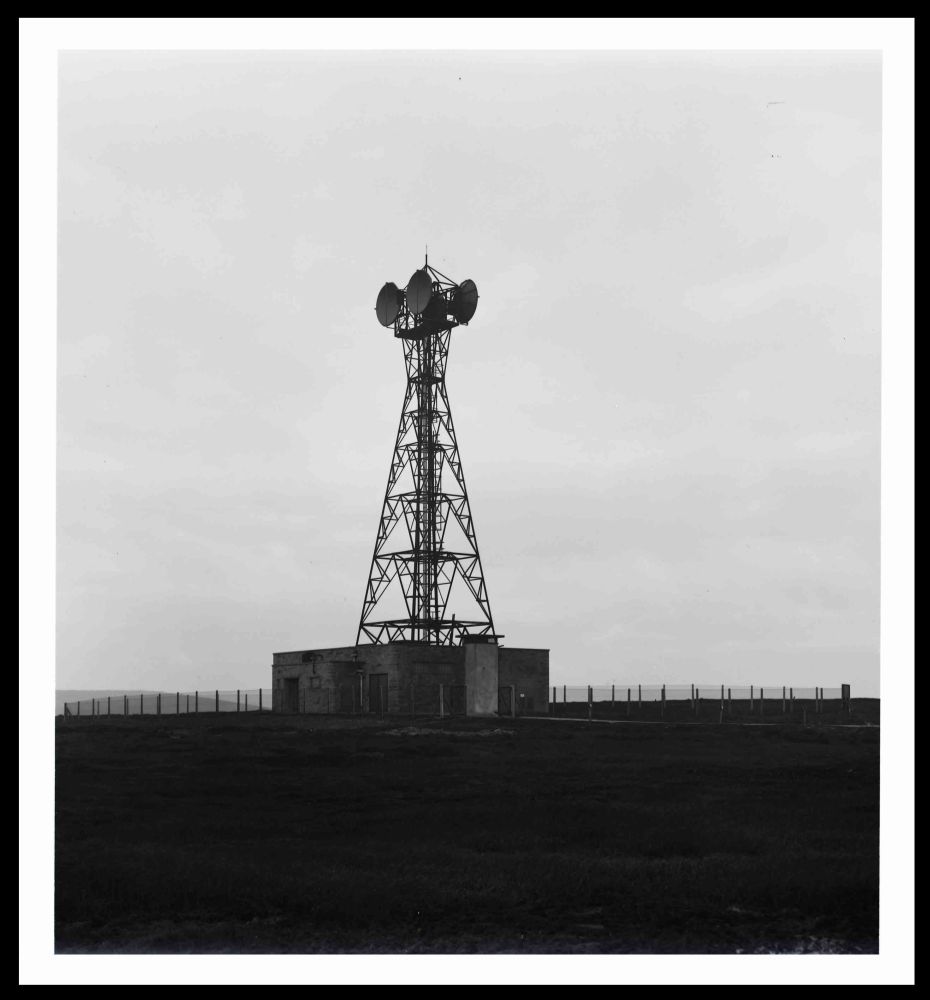
Windy Hill was initially established as part of the 1951 Manchester to Kirk o'Shotts television route [link to feature]. The site is on the Pennines close to the Lanacashire/Yorkshire border and linked the Manchester terminal station with Tinshill near Leeds. As with the other sites on this route the initial provision was a relatively short steel tower carrying a pair of dishes facing in each direction, together with a brick building for the equipment, including standby generator.
The Emley Moor television transmitter entered service in 1956 and until 1968 served the "North of England" with a programme feed from Manchester. The 1959 Network Map shows this additional link at Windy Hill. At that stage a separate site at Saddlesworth was "programmed" as part of the "Backbone" route - this would link directly from Sutton Common to Hunters Stones, avoiding Leeds and Manchester. In practice there were problems acquiring the site and Windy Hill therefore became part of the Backbone route. This resulted in a requirement for a taller structure (also at Hunters Stones) and subsequent need to switch the different types of traffic between the available frequency bands.
The Backbone link entered service around 1963 and initially operated on the 6 GHz band using a "large" horn facing Hunters Stones at the very top of the tower. A second horn at lower level faced Sutton Common. It is unclear whether the 1951 route was still operational but this would have been at 4 GHz and the local link to Emley Moor understood to be on 2 GHz.
Wider network development in the 1960s resulted in the potential for additional traffic between Manchester and Leeds, including links for Yorkshire Television. The link to Emley Moor was re-arraged to run via Tinshill and to allow more efficient use of the avialable frequency bands the Backbone traffic was re-allocated to 2 GHz between Hunters Stones and Sutton Common - the high-level horn at Windy Hill was then removed. The new allocation allowed full use of the main bands between Heaton Park and Tinshill.
The large square tower is the result of the site's dual purpose - without the Backbone link it's likely a shorter and lighter structure would have been sufficient. Ice protection shields were fitted above the main dish positions however in 1976 falling ice caused significant damage to the antennas and the roof of the building. The Backbone links were taken out of service during 1989 and by 2005 the remaining dishes faced Heaton Park and Tinshill only, with the top third of the tower empty.
Final cleaance of the main dishes seems to have been between 2013 and 2015 but the structure remains in use for mobile phone operators and local linking. Strengthening work was undertaken in 2015 by LARS. The main building is of the "standard" pattern, with no trace of the 1951 building or original tower. Curiously OS maps dated 1956 and 1968-72 do not show the site,b but it appears by 1981 "TV & Radio Station" with the "mast" and two buildings.